


About two and a half years ago, we drove from Argentina into Chile via Paso de Jama. On the Chilean side, the monumental bulk of Licancabur suddenly loomed to our right. The sight of this “monster” stopped me in my tracks, and I knew then I had to stand on its summit one day. From that moment, the urge to climb Licancabur never left me.
Here we go!
When our travels in Bolivia finally brought us to Laguna Salada, we were suddenly close enough to try. We’d already been on the Altiplano into our second week, so we were at least partly acclimatized. Iva was battling a respiratory infection, so in the end it was just Braňo who set out with me — and he gave the climb an unforgettable vibe.
We’d planned to hire a local guide, but in classic last‑minute fashion — as with most things on this Bolivia trip — finding one on a day’s notice didn’t work out. Thankfully, a woman at a local agency still shared the basics over WhatsApp: key details about the route to the top and current conditions.
Preparation is everything
The trailhead was about an hour’s drive from our lodging. We set the alarm for 3:00 a.m. and prepped the night before, so in the morning we slipped into the car and headed out quickly, crossing the Salvador Dalí Desert toward Laguna Verde and Laguna Blanca.
It was by these lagoons that we first glimpsed the bulk of Licancabur. But it was still pitch-dark; all we could make out was a faint wash of moonlight on the snowcapped summit. The sheer height awaiting us was, honestly, intimidating.
After a nighttime hunt for the correct track between the lagoons, we reached the start just before five. We also got lucky — a gate on the road a few kilometers earlier happened to be open. Likely because we weren’t the only ones attempting the climb that day: at the trailhead we saw a car belonging to a local travel agency.
The endless ascent
In bitter cold, we began to climb. For navigation in the dark we used Mapy.cz (Mapy.com), though the path was mostly easy to follow even at night. After about two hours, the sun finally rose, its rays slowly flooding the valley of Laguna Verde and Laguna Blanca. The morning light lifted our spirits and took the edge off the cold.
With every meter gained the air grew colder, and the lack of oxygen became more noticeable. Nothing dramatic, but the fatigue crept in. The remedy was more frequent breaks, after which you feel okay again — until the first few steps, when the tiredness returns. Even the smallest tasks — swapping a layer, fishing a thermos from the pack, handling a bit of gear — grew surprisingly difficult.
The mountain of false summits
Sunlight brought another advantage: we could finally see where we were headed. From past experience it seemed the summit ahead wasn’t all that far, and we might just pull it off. After a short break and breakfast we pushed on. The slope steepened, but the path remained simple and easy to follow.
What we didn’t realize at first was how much time our frequent pauses were costing us. The first reality check came around eleven, when GPS still showed us below 5,500 meters above sea level. It also became clear this mountain was playing tricks on us. What we took for the top was always just a break in the slope — and beyond it, another stretch that felt endless. That scene replayed at least four more times. It didn’t do our morale any favors.
Turn back or push on?
Seeing time slip away faster than we needed, I suggested to Braňo that maybe it would be wiser to turn around. He disagreed and said we should still try for the top.
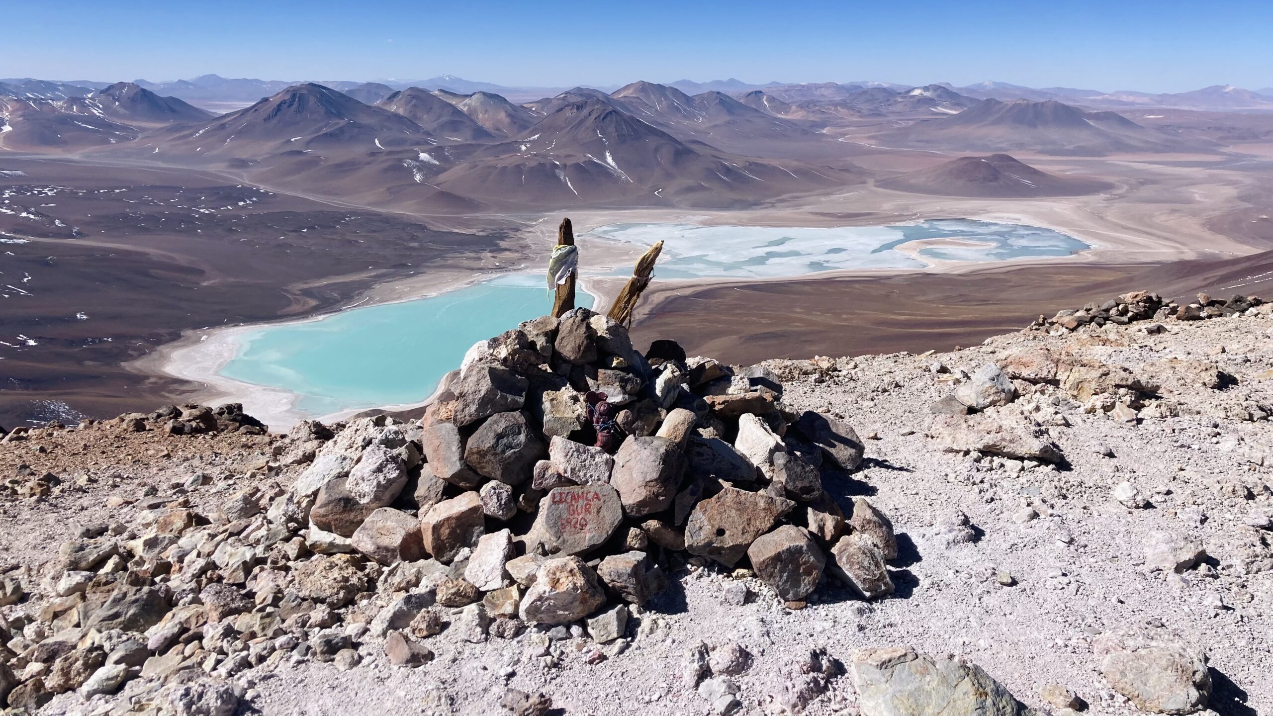
Just as we started gasping for air and my doubts about a safe timeline grew stronger, the terrain began to ease, and GPS showed us just below the crater rim. I picked up the pace. After a few minutes I spotted a stick planted in a pile of rocks — the summit marker.
I peered into the crater, long filled with water — essentially a frozen lake. A few minutes later Braňo topped out as well. Tired but happy, we took a photo together and turned to the endless views.
But the watch was unequivocal — we needed to head down as soon as possible. It was nearing three in the afternoon, and we had roughly four hours of descent ahead.
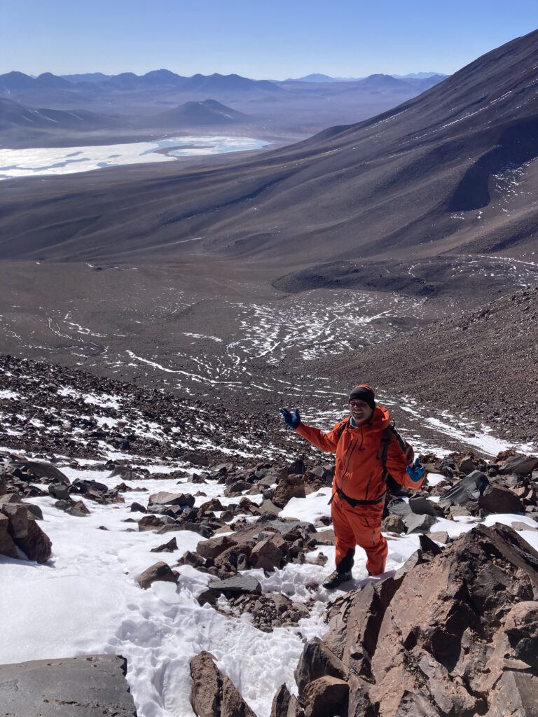
The endless descent
I thought the worst was behind us, but the descent turned out to be the most critical part of the day. It became clear that in his push for the summit, Braňo had overestimated his reserves. He was moving much slower than I was on the way down, and it was obvious we wouldn’t reach the car before dark.
My efforts to spur him on didn’t help much — he was doing all he could. The final stretch became a race for the last rays of sun and the last scraps of warmth. Shortly after sunset the wind picked up, and the final hour was rough: cold biting me to the bone, and for Braňo, pure exhaustion.
A happy ending
In the end, all was well. Braňo made it without an injury that would have complicated everything, and around seven in the evening we finally reached the car — exhausted, frozen, but safe.
Lessons from Licancabur
Licancabur gave me more than just another summit to tick off. It reminded me that at high altitude it’s not just willpower and fitness that count, but above all time, humility, and the ability to make the right calls even when the goal is within reach. The mountain doesn’t forgive mistakes, and every extra meter takes its toll.
If I had to take one lesson from this climb, it would be this: the summit is only half the journey — getting down is often the more important part.
Licancabur — at a glance
Elevation: 5916 m a.s.l.
Location: the Bolivia–Chile border
Volcano type: stratovolcano (dormant)
Ascent profile: technically straightforward, physically and mentally very demanding
Main risks: altitude, wind, cold, underestimating time and the descent
Fact: the crater holds one of the highest lakes in the world