


Say “Andes,” and most people picture extreme heights, snow and thin air. The reality is far more complex. The Andes aren’t a single, uniform massif—their elevation, character and visual impact change dramatically from north to south. And, more intriguingly, how high the Andes feel often doesn’t match the numbers on a map.
This piece looks not just at elevation, but at something called prominence—and at what you might call the illusion of height: how landscape, climate and contrast shape the way we experience mountains.
Absolute elevation: numbers that don’t tell the whole story
Absolute elevation is the measure we know best—how many metres a summit rises above sea level. By that measure, the Andes are home to South America’s highest mountains, including Aconcagua (6 961 m).
Equally important are areas like the Altiplano, where whole regions sit at “only” around 3 500 – 4 000 metres. You can work, travel and live here; it’s not a classic alpine environment. Altitude registers differently than in a traditional high-mountain massif.
Prominence: why some mountains take your breath away more than others
Prominence describes how much a peak rises above its immediate surroundings. Simply put: if you wanted to continue from that summit to something higher, prominence tells you how many metres you’d first need to descend to the lowest connecting saddle.
Prominence is why lower peaks can feel more monumental than higher ones. Think of Patagonia’s steep towers, which seem bigger than the figures suggest. It also explains how you can stand on a flat high plateau and still be at extreme altitude.
Prominence is the key to understanding why the Andes don’t look equally high everywhere.
The illusion of height: when the landscape tricks the senses
To round this out, it isn’t just metres that shape your sense of height. Colours, vegetation, humidity, cloud cover and the contrast between mountains and their setting all matter—and this is where the Andes start behaving very differently.
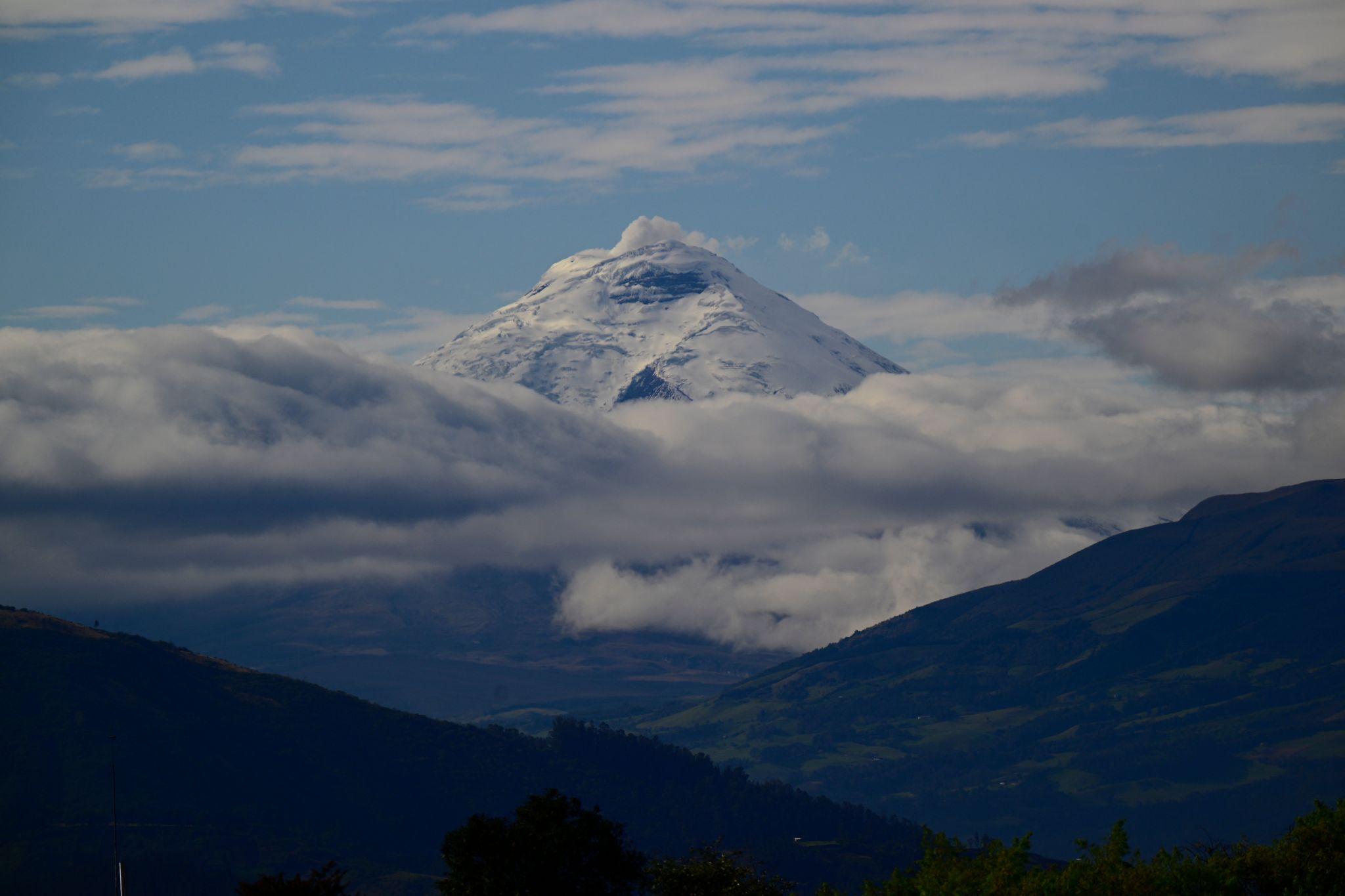
Northern Andes: green and humid Ecuador
Ecuador’s Northern Andes feel surprisingly green and wet. Even at high elevations there’s vegetation, cloud cover and regular rain. The mountains seem less inhospitable—more dramatic, very much alive.
A striking contrast: summits here are often more clearly snow-covered than volcanoes of the same height on the Altiplano. Snow isn’t an exception—it’s part of the landscape.
You feel the altitude, but the landscape softens it visually. Greens, cloud and moist air make the mountains seem closer, bulkier and at the same time more approachable.
Altiplano: elevation without greenery, but with space
A completely different world awaits on the Altiplano in Bolivia and adjoining parts of Chile and Peru. The land is extremely dry, almost without greenery, yet paradoxically full of lagoons in varying colours. Horizons are wide open, distances deceive and any sense of scale can disappear.
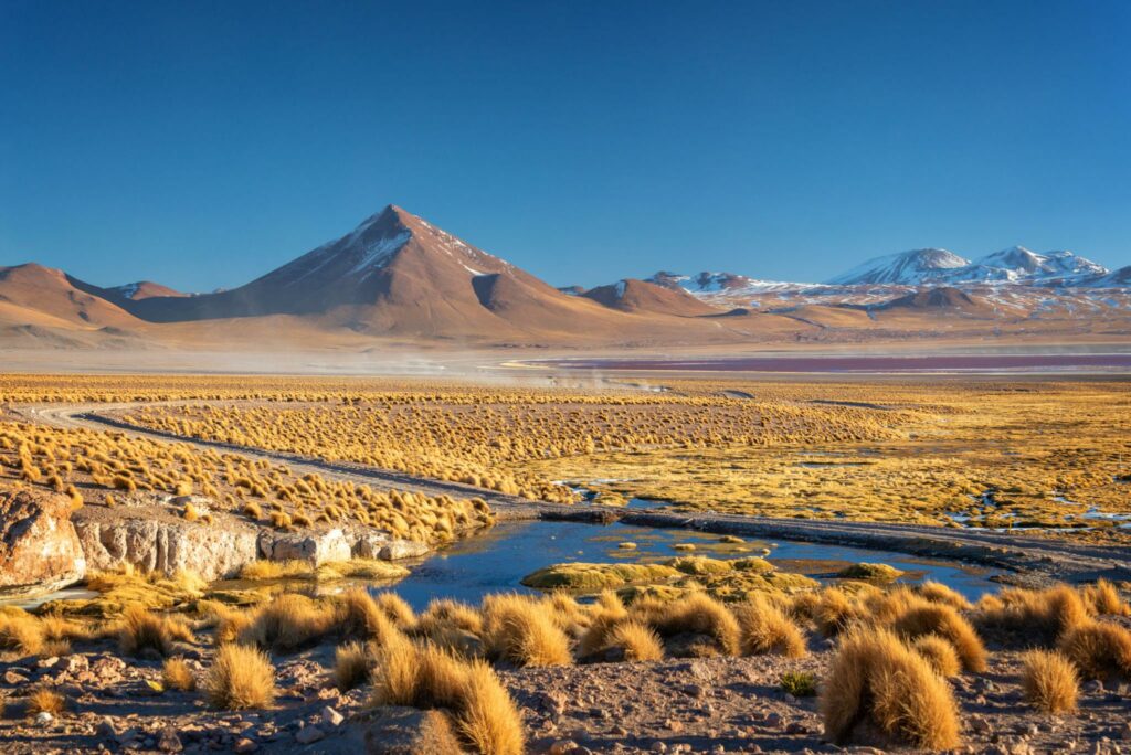
Hills and volcanoes are often relatively easy to reach; in places you can drive to very high elevations, sometimes almost to a summit. One example is the track up the flanks of the Uturuncu volcano.
By day the strong sun makes it relatively warm. At night temperatures plunge, and the reward is an almost perfectly clear sky with exceptional views of the stars.
The Altiplano is a place where altitude doesn’t look dramatic, yet it’s always there—in your breathing, your sleep, your fatigue.
Patagonian Andes: lower numbers, a stronger impression
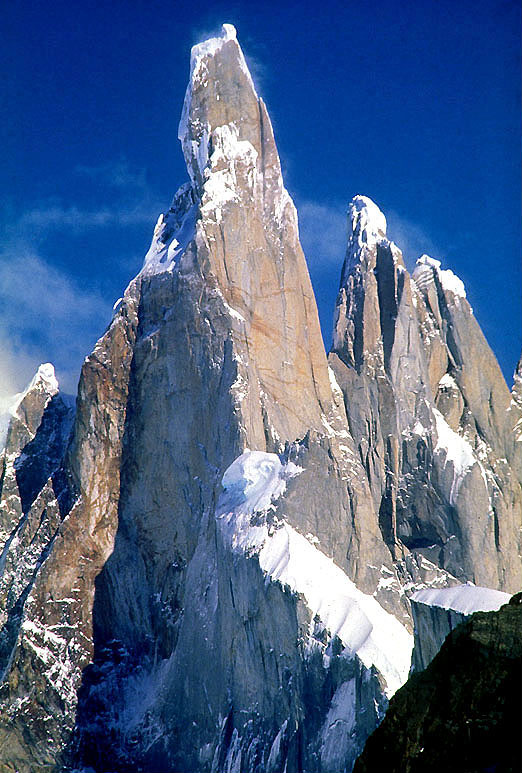
While the Patagonian Andes don’t reach extreme elevations, their prominence and rugged relief make them some of the most visually striking mountains on Earth. Peaks rise steeply from their surroundings, often almost from sea level.
Glaciers, vertical walls and fast-changing weather make the mountains feel higher than they really are. Here the illusion of height works the opposite way from the Altiplano—numbers are lower, the impression is extreme.
Among the best-known Patagonian spires are Cerro Torre and Fitz Roy (Cerro Chaltén), the iconic granite towers near the town of El Chaltén. Other prominent summits include Cerro Torre Sur, Cerro Torre Egger and the Cerro Torre Standhardt massif. Although their elevations seldom exceed 3 500 metres, their extreme prominence and sheer faces make them among the world’s most imposing mountains.
Colombian Andes: high mountains in a tropical setting
The Andes in Colombia are less famous than those in Ecuador or Peru, but the contrasts are remarkable. Here the range splits into three main branches—the Western, Central and Eastern Cordilleras—with the deep valleys of the Magdalena and Cauca rivers in between. The result is a landscape where you move from lowlands to high mountains with striking speed.
One of Colombia’s most interesting Andean regions is the Cordillera Central, home to the country’s highest active and extinct volcanoes. Peaks such as Nevado del Ruiz and Nevado del Tolima rise above 5 000 metres and, despite lying near the equator, are often capped with snow and glaciers.
Another distinctive Andean setting is the Cordillera Oriental, especially the Sierra Nevada del Cocuy. It’s one of the few places in the northern Andes where extensive glaciers, sharp peaks and high plateaus remain. Tropical latitude, high elevation and frequent cloud create a strong contrast between green valleys and a cold alpine world.
The Colombian Andes don’t feel vast because of breadth or broad plateaus, but because of the abrupt jumps between climates, vegetation zones and elevations.
The Andes aren’t one mountain range, but many worlds
You can’t judge the Andes by altitude alone. To understand them, you have to consider several factors.
Green, humid Ecuador; the dry, open Altiplano; and dramatic Patagonia all show that height comes in many forms. Before you head to any part of the Andes, read up as much as you can so you know what you’re getting into and what to pack. Whichever corner you choose, you’re unlikely to regret it—this is a truly singular and beautiful part of the world.
Facts about the Andes
- Highest peak: Aconcagua (6 961 m a.s.l.) in Argentina is the highest summit in the Andes and all of South America.
- Length of the range: The Andes are the world’s longest mountain chain—stretching about 7 000 kilometres along the western edge of South America.
- Countries they pass through: Venezuela, Colombia, Ecuador, Peru, Bolivia, Chile and Argentina.
- Altiplano: one of the highest inhabited plateaus on Earth, with an average elevation around 3 700 metres.
- Glaciers in the tropics: The Andes are the only mountain range in the world with glaciers lying within the tropical zone.
- Tectonic origin: The Andes formed through the subduction of the Pacific Nazca Plate beneath the South American Plate.
- Climatic diversity: Within the Andes you’ll find deserts, rainforests, high plateaus and glaciated areas—often surprisingly close to one another.