


I arrive in Guadeloupe planning to hop aboard my friend Braňo’s catamaran and try a few days of life at sea in a part of the world that’s new to me—the Caribbean. The original plan leaves me a day or two of free time, so I rent a car to explore the island a bit on my own.
I’m also toying with an optimistic idea—if conditions allow, I’d like to climb La Grande Soufrière, the island’s highest point.
But plans shift when Braňo sails into Guadeloupe a few days earlier than expected. He and his crew join me, and the four of us head out for a hike in the area below La Grande Soufrière.
The day ends up reflecting everything—the unhurried pace of people who’ve spent more time at sea than on land lately, the weather, and the fact that we miss the correct trailhead right at the start.
Instead of a volcano ascent, we end up on a shorter jungle hike to Carbet Falls. It wasn’t the original plan, but it turned into a really good day of hiking, views, and swimming by the falls.
A change of plan right at the start
From the start, it was clear the conditions weren’t ideal. The highest ridges were cloaked in cloud and visibility was poor—pushing for the summit wouldn’t have made much sense in this weather.
We also hit a practical hiccup right at the start.
We missed the turnoff for the road to the upper lot, Parking Chutes du Carbet. Instead, we ended up much lower down at a little-known parking area tucked into the forest—right at the start of the Trace de la Troisième Chute du Carbet.
In hindsight, that was a lucky break.
A lesser-known route
Because we didn’t start at the main parking lot, we likely also skipped the entrance fee that’s usually collected at the official access point.
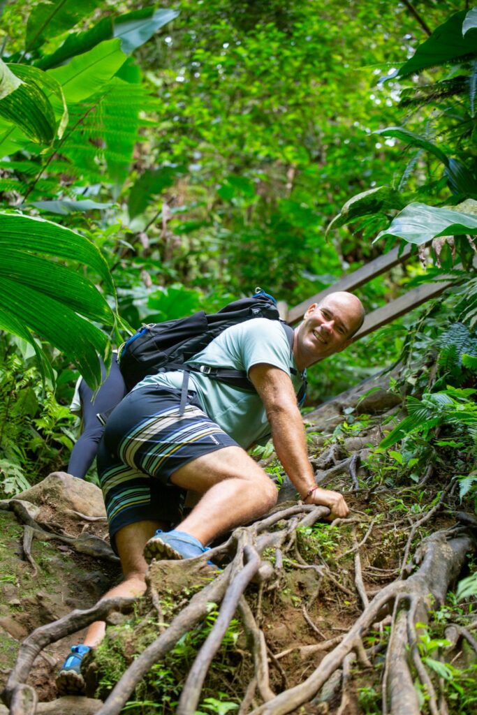
The route we took sees far fewer hikers, yet it’s still reasonably well maintained. Right away we were surprised by wooden boardwalks and small bridges clearly built to span sections that turn into mud traps during rain. This side of the island is much wetter, the jungle is dense, and the ground soaks up water quickly—those walkways earn their place.
Troisième Chute du Carbet waterfall
We sink gradually deeper into tropical forest. The air is heavy with humidity and alive with the sounds of the jungle. This isn’t the kind of hiking we’re used to in Europe.
After about half an hour we reach the first junction. The names on the local signs don’t mean much to us—we hadn’t researched this variant at all. We turn left toward the river and carry on without high expectations.
So the surprise is all the greater when the view suddenly opens onto Troisième Chute du Carbet.
The waterfall feels natural and a little wild—untouched by major interventions. The path leads to a viewpoint, but getting right down to the water takes a bit of picking your own way through branches, roots, and rocks. It’s not technical, you just need to tread carefully.
Despite the sign, we can’t resist and scramble down to the pool. The cold water beneath the falls is exactly what you crave after a warm, humid hike. We don’t hesitate—we get in.
We linger longer than planned—helped by the fact that we have the place entirely to ourselves. The first people arrive just as we’re packing up to leave.
Deuxième Chute du Carbet viewpoint
From the waterfall we head back to our original path and continue climbing alongside the Rivière du Grand Carbet.
This stretch is the toughest of the whole route—not so much technically, but because of the steeper gradient and a few places where you need to read the terrain. In some sections the path isn’t obvious and you have to choose the right line. If in doubt, check your position on a map—the trail is drawn quite accurately.
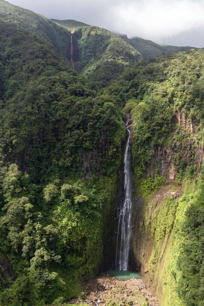
After a longer climb the terrain gradually eases and joins the official route to the viewpoint of Deuxième Chute du Carbet. The whole hike changes character here. The narrow jungle path gives way to a wider, manicured, well-marked trail with steps, railings, and far more visitors.
A few minutes later we arrive at the viewpoint for Deuxième Chute du Carbet.
The viewpoint offers a good, if slightly limited, look at the falls and the higher slopes, which during our visit stayed wrapped in cloud. It only confirms that trying to go higher wouldn’t have made sense today.
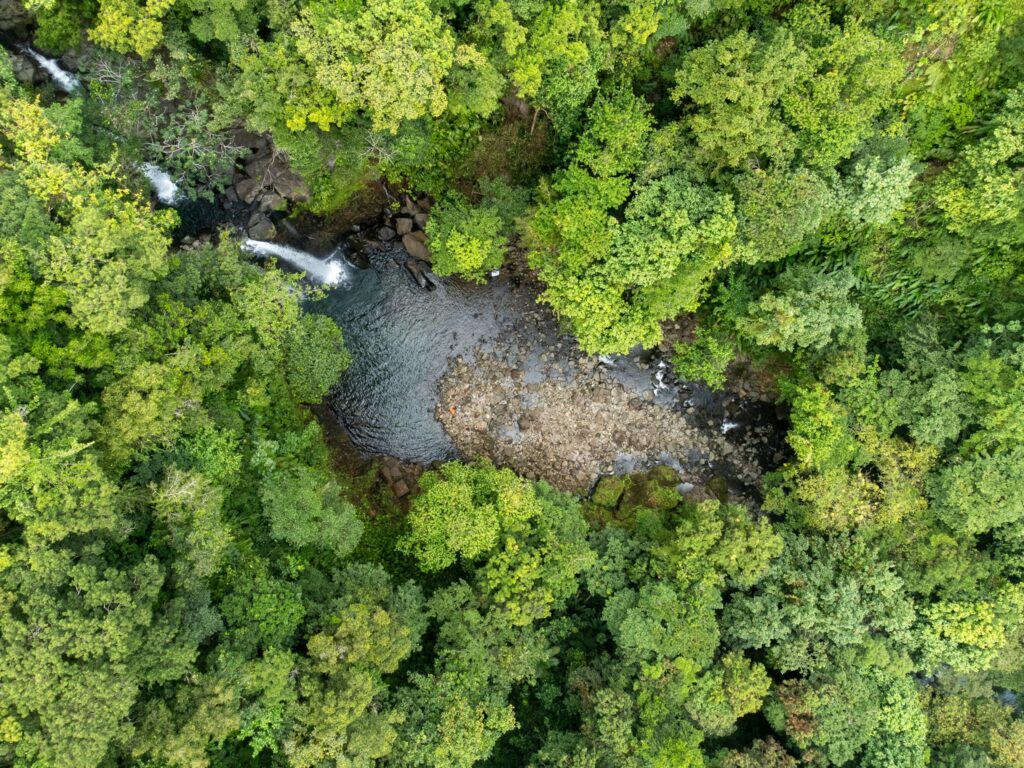
The official trail ends here, so we take a short break, eat something, and head back the same way. Before that, though, we send up the drone to capture the waterfall from better angles than the viewpoint allows. The aerial shots also reveal the first of the trio—Première Chute du Carbet.
About Carbet Falls
Carbet Falls (Les Chutes du Carbet) are set within Guadeloupe National Park (Parc national de la Guadeloupe) on the flanks of La Grande Soufrière on the island of Basse-Terre.
They’re a trio of waterfalls—Première, Deuxième, and Troisième Chute du Carbet—among the island’s best-known natural sights. The highest, Première Chute du Carbet, drops more than 100 meters.
The best time to visit is outside periods of heavy rain, ideally in the drier part of the year. Thanks to frequent rainfall the falls are powerful year-round, but during intense downpours trails can be very slippery and some sections may close.
Conclusion
By late afternoon we’re pleasantly tired and full of the day’s adventures, heading back to the marina and the catamaran.
It was well worth it—even though the plan morphed as the day went on and, instead of the island’s highest peak, we got to know the local jungle a little better.
Paradoxically, that bit of improvisation made it one of the best days on the island. Less fixation on the goal, more space to react to conditions—and a stronger experience because of it.
A swim beneath the falls, the solitude of the jungle, and views of the higher tiers made it a day we’ll remember for a long time.
Route essentials
Distance: about 4.5 km
Total elevation gain: about 360 m
Total time (including return, breaks, and swimming): about 3.5 hours
Recommended gear: plenty of water, sturdy footwear, insect repellent