


In late summer 2020, we set out to spend two days and one night in Poloniny National Park, at Slovakia’s far‑eastern edge near the Slovak‑Ukrainian‑Polish border. The plan was simple: see for ourselves if the myths about Poloniny’s pitch‑black night sky hold up—the very reason people travel here from far away.
A long drive to the end of Slovakia
We reached Poloniny by car after a fairly long drive from Bratislava. Bit by bit we closed in on the village of Nová Sedlica, our intended starting point. Just before the village we pulled over to get ready for the hike—changing clothes, unloading and repacking our backpacks, weighing what to take and what to leave in the car. No one wants to lug extra kilos for nothing.
Soon a border‑police car pulled up beside us. They didn’t ask anything, so we didn’t start a conversation either. We were, after all, in one of Slovakia’s most closely watched border areas, so their presence came as no surprise.
We left the car at the very end of Nová Sedlica and, fully loaded, set off along the red‑marked trail toward a place called Temný vŕšok.
The climb up to Temný vŕšok
Temný vŕšok is a ridge section with a few open spots free of dense forest. That’s where we planned to pitch the tent and enjoy views of the night sky. The weather was on our side—cloudless and crystal clear.
The climb wasn’t exactly easy. It had been a while since I’d hauled a tent, sleeping bags, mats and the rest of the kit uphill. Still, for good views and a memorable night, we shoulder the load.
The steepest part is at the very start, up through Skládka pod Kýčerou. The gradient eases noticeably after about an hour of walking. Another hour brings us to our first goal.
Temný vŕšok is actually where the red trail crosses an unmarked path running along the ridge. We turn onto this unmarked option and start looking for a place to camp. Truth be told, it’s more wooded than I expected, and in most places the views of the sky are fairly limited.
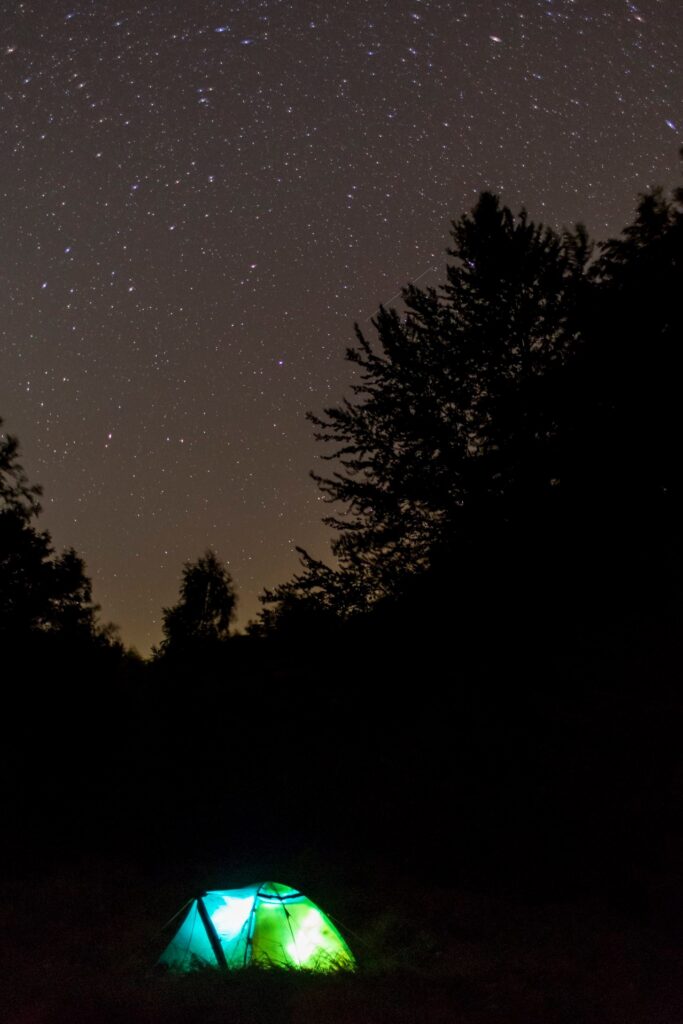
Eventually we find a small clearing that leaves a generous slice of sky open. We don’t feel like searching any further, so the decision is made—we’re sleeping here tonight.
An evening under the stars
There’s still plenty of time before sunset, so everything is calm and unhurried. Dinner is Iva’s excellent rolls, washed down with absinthe and fresh grapefruit juice. Clearly, we didn’t skimp on preparation.
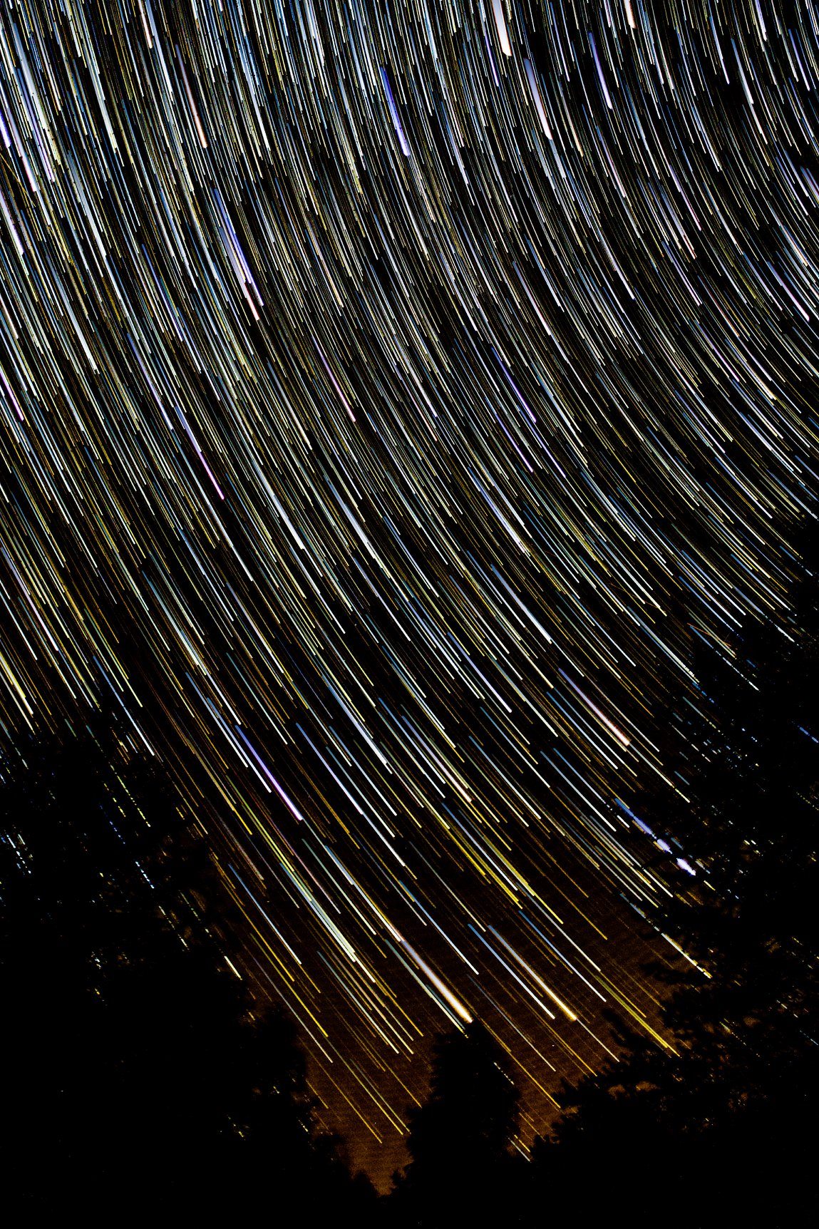
In good spirits, we watch the sky slowly change color. The sun itself hides behind the dense forest and slips below the horizon. Before long the first stars appear. Expectations are high—I know how powerful it is to see the Milky Way, even distant galaxies. The question is whether that’s possible in Slovakia, a country otherwise almost entirely veiled in light pollution.
Before midnight the sky is fully dark and there are truly countless stars. The Milky Way comes into view. The sight is stunning and our hopes are met. We lie on mats on the ground and watch this night‑sky theater. You could stare for hours, but the cold gradually drives us into the tent. We still dash out a few more times to soak up the moment. Of course I’d lugged a tripod and DSLR, so a few night shots come to life too.
Shortly after midnight we retreat to the tent and straight into our sleeping bags—the cold had become too much.
Morning in Poloniny
In the early morning I’m surprisingly cold in the tent, while Iva complains she’s too warm. We swap sleeping bags and we’re both comfortable. It’s still dark outside, so we allow ourselves a bit more sleep. Daylight finally wakes us.
We pack away the tent, all our bits and pieces, and think about what’s next. Our next target is Mount Kremenec. We don’t feel like carrying the tent and the rest of the overnight gear, so I check the map and find a way to make a small loop without retracing our steps.
That lets us leave part of the kit near where we camped. We stash a backpack full of things we won’t need in the nearby brush and continue along the red trail, planning to pick it up later.
To the Stužická River and beyond
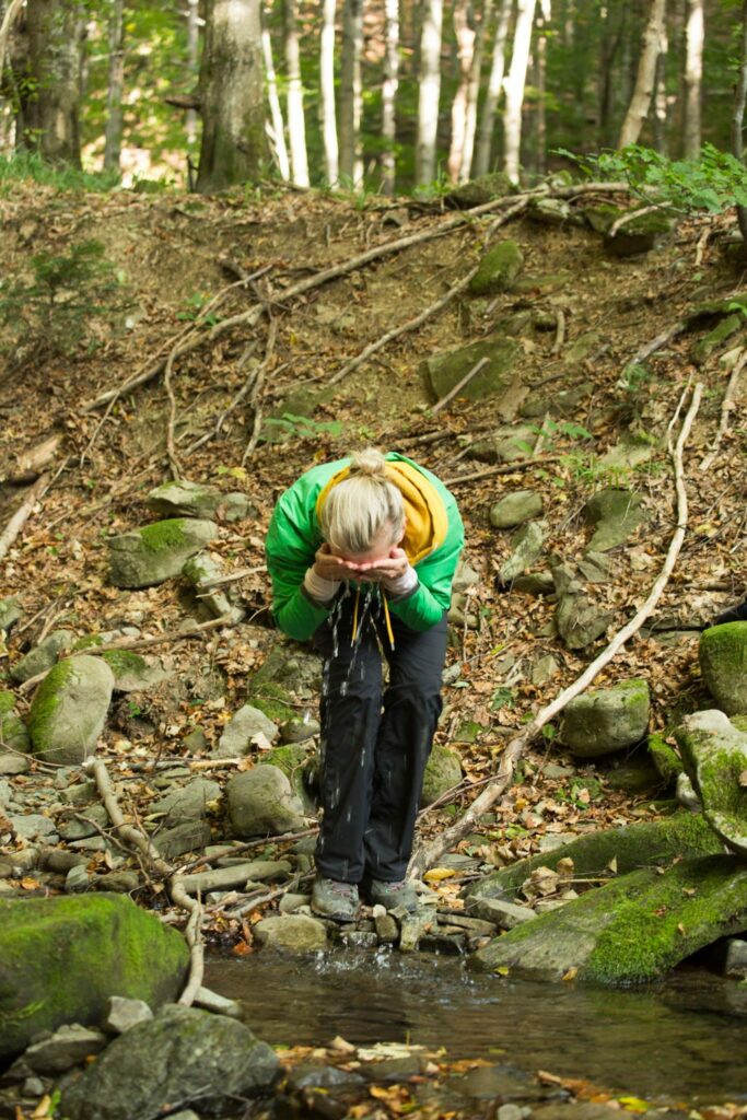
The trail then drops into the valley to the Stužická River. Where the path crosses it via a small bridge, we stop to make breakfast. It’s the perfect spot—running water, a bridge that doubles as a bench, and deep quiet all around. Pure morning romance.
After a quick bite and a bit of morning wash‑up we push on toward Kremenec. The trail starts to climb again, but nothing too intense. After about an hour we reach the Slovak–Ukrainian border. Beyond boundary stones and posts, it’s unmistakably defined by a broad treeless swath running its length—a bold line in an otherwise continuous forest.
From here it’s only a short distance to the tripoint, though in relatively steep terrain. It’s worth noting that the Slovak, Polish and Ukrainian borders don’t meet on the very summit of Kremenec. That lies farther east, already outside Slovak territory.
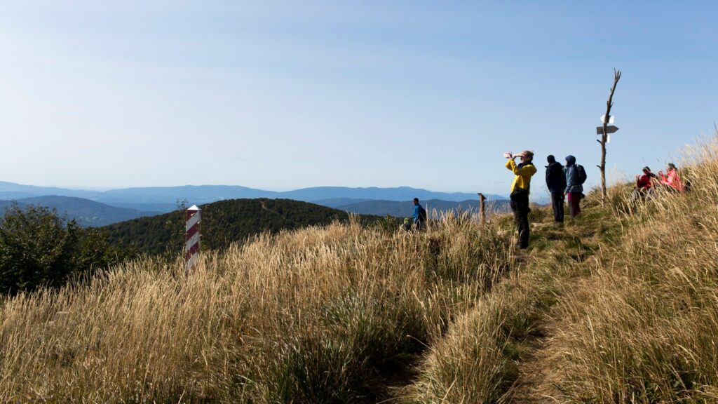
What’s interesting for hikers is precisely the spot where the borders meet. A stone monument marks the point. The red trail (Východokarpatská magistrála) meets a blue trail arriving from the Polish side. There are a few benches here, and a spring rises nearby on the Slovak side of the line.
We find ourselves here almost completely alone. Mission accomplished. I’ve never even been to Košice, yet I’ve made it to Slovakia’s easternmost point.
After a few photos we continue to the actual summit of Kremenec. Unlike the tripoint, there’s only a boundary stone here; nothing else marks the top. It doesn’t even lie directly on the blue trail, but a short way off it. The peak reaches 1 221 m a.s.l.
From this otherwise modest summit we can see the nearby Wielka Rawka (1 307 m), already across the border in Poland. It looks like a stone’s throw away, but a fairly deep saddle separates us. Even so, we can’t resist and set off in its direction.
About 40 minutes later we’re on top of a hill we hadn’t planned to climb. The summit is broad, yet it still offers fine views. The weather is perfect, and we end up spending more time here than on Kremenec.
Time, however, to start making our way out. We return to Kremenec and find that being here early has its perks—around midday there are far more people. We continue along the Slovak–Polish border on the red trail toward Čierťaž.
The route alternates between forest and small meadows, keeps to the ridge, and every so often we pass another boundary stone. It’s straightforward, following a dirt track. Though the terrain ripples up and down, we’re essentially dropping about 150 meters overall.
Along the way we pass one of the larger open meadows, Kamenná lúka (1 200 m). Here the trail leaves the forest entirely for a stretch and the views open in all directions. Had we known about this spot earlier, we would probably have chosen it for stargazing.
At the Čierťaž saddle we join the green trail and begin our descent off the ridge. We drop to a place called Lúky pod Príkrym, where we leave the marked route and head back toward where we left the backpack, not far from Temný vŕšok.
Although it’s an unmarked section, navigation is easy—the track is wide and we get back to our backpack without issue. Thankfully no one has taken it, which of course makes us happy. Less so the fact that from here we’re back to carrying full packs.
The steep initial ascent turns into an endlessly long—and at times uncomfortably steep—descent back to the car. On the final stretch our shoulders are both burning from the weight we’re carrying.
One way or another, we eventually make it to the car—successful, if thoroughly spent. Delighted with a hike well done, we leave this far‑eastern corner of Slovakia. The stars stay with us for a long time, a memory that will keep nudging us to seek out equally dark places wherever we roam.