


Our very first experience with altitude in the Andes came sooner than we would have liked: a trip to Quilotoa Lagoon in Ecuador. We set out the very next day after arriving in Quito. In hindsight, not our best idea.
After landing in the capital, we picked up a car at the airport and drove south. We ended the day near the town of Machachi. After a long flight with connections, we barely registered where we were. We said a quick hello to our host, collapsed into bed, and fell asleep almost instantly.
We didn’t sleep long. Jet lag had our body clocks completely scrambled. Around five in the morning I stepped outside and stood in silent awe at the scenery around us. We were in a small village, with volcanoes, hills, and snow-capped summits etched across the distance. A veil of mystical clouds hung over everything as the morning sun broke through. The humidity was striking too—it almost felt like waking up in a rainforest.
A quick look at my phone revealed our elevation—about 3,100 m a.s.l. Okay, we were high up. I headed back to the room hoping to catch a few more minutes of sleep. I managed a short doze before Iva woke up and the morning routine began. We both noticed it was distinctly colder than the evening before.
We still hadn’t quite grasped what conditions we were in, so after breakfast we packed quickly and headed straight for our first goal—the Quilotoa crater.
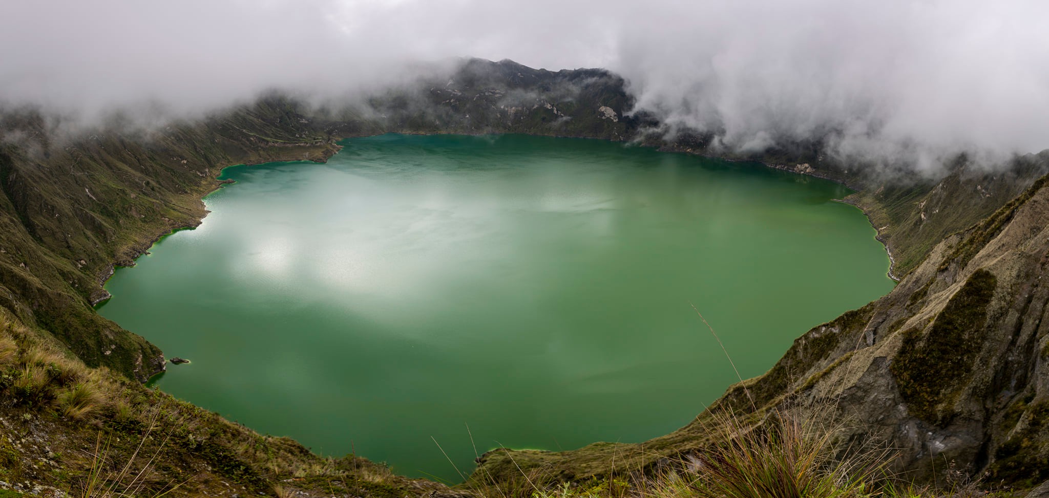
Quilotoa Crater
Quilotoa Crater is part of an extinct volcanic massif and is ringed by a striking mountain ridge with several viewpoints. The full loop around the crater is a popular all-day trek, with the high point at Monte Juyende, roughly 3,930 m a.s.l. Even just reaching the rim puts you at an altitude we were nowhere near ready for.

The crater is easy to reach by car and is among the most visited natural attractions in this part of the country. Despite that, we arrived relatively late. Regular landslides had blocked our route. We eventually parked in a small settlement at the foot of the crater and set off at a brisk pace for a short walk.
The rim lies just beyond the parking area, and within minutes the view opened down into the crater—onto Quilotoa Lagoon. Despite the extreme altitude, everything around us was green; at moments it even felt a bit like the countryside back home. That impression didn’t last: the lagoon’s unbelievable colors, the crater’s steep rock walls, and llamas darting about quickly broke the spell.
There’s a path down to the crater floor, but my eyes went to the highest point—Monte Juyende—which looked almost within reach, separated from us by nothing more than a small grassy, rocky saddle. The trail was obvious, straightforward, and non-technical. We set off toward the high point. The weather was on our side—the breeze was light, and the sun slipped through the clouds now and then. Tired as we were, the path felt easy and the summit looked like something we could tag any day. But this wasn’t just any day.
The first signs of trouble
Iva was the first to struggle. We hadn’t even reached the saddle when she said she was tired and suggested turning back. It was still slightly downhill to the saddle and I felt fine, so we agreed to split and meet at the car. It didn’t feel like a big decision—the terrain was simple, the route obvious, and there was still plenty of daylight. Iva turned around; I continued.
I reached the saddle in a few minutes. All that remained was about 230 vertical meters in relatively easy terrain. I started up. After the first few meters I felt as if I’d run a marathon. I tried to catch my breath, took a short break, and pushed on. Twenty more meters and I felt like I’d just finished another marathon.
That repeated itself about five more times. On the fifth try I checked the map and realized I hadn’t even gained fifty vertical meters. Each step felt harder than the last. I sat on a rock and thought. The way back to the car led over the saddle and then involved another climb—about 150 vertical meters. If I couldn’t comfortably manage fifty now, how was I going to get over 150?
Crisis

Bagging Monte Juyende would have to wait. It was clearly time to head back. I turned around and set off after Iva toward the car. Getting to the saddle was easy; the problems began with the climb. The pattern repeated—a few meters up, five minutes catching my breath, a few more meters, another long pause. At first it was almost funny; then came despair. “Is this even possible?” I asked myself.
I could literally feel my strength draining away. I tried to brace and push with my hands, which only drained me further. I started to feel cold. I layered on everything I had in my pack. I drank a lot—so much that it was clear the water in my CamelBak wouldn’t last long.
At last the terrain leveled out and I could see the village where we’d parked. I was still shivering and exhausted, but at least I picked up the pace. Over the final stretch I felt as spent as after a tough winter hike in the Tatras. A café called Sinchy Tupak saved the day. Iva was already there and had wisely ordered us coca tea. The despair and fatigue ebbed away. The tea was a genuine rescue—the coca leaves lifted our energy and the will to keep going. The car was just a short walk away.
The lesson
Quilotoa Crater is a visually powerful place and deservedly one of Ecuador’s icons. But we also got a valuable lesson—and it didn’t have to be this way. First, we badly underestimated sleep and the overall fatigue from the flight. Second, and crucially, we had zero acclimatization.
Right after landing we found ourselves at elevations around 3,000 m a.s.l., which is a shock to the body on its own. That wasn’t enough for us, and the very next day we tried to reach a summit close to 4,000 m a.s.l.
On later Andean travels we met other eager hikers much like we’d been then. Some weren’t spared serious health problems. In that sense we were lucky—we pushed ourselves to the limit but walked away without lasting consequences. The lesson stuck for life:
“If you’re not acclimatized, you simply don’t go to 4,000 m.”
These days we treat acclimatization as non-negotiable on any mountain outing.
Facts about Quilotoa Crater
- Type: extinct volcanic crater
- Highest point: Monte Juyende – approx. 3,930 m a.s.l.
- Lagoon in the crater: mineral, with shifting water color
- Hiking options: viewpoints, descent to the lagoon, full-day circuit around the crater
- Difficulty: technically easy; physically moderate to high (because of altitude)