


After a grueling haul from Laguna Salada, we’re finally settled into the warm, spacious dining room of our guesthouse in Quetena Chico. A few hours ago, sunshine kept this space cozy; now, in the chilly evening, a small stove in the corner does the job.
We’re not here by chance. Ever since my first visit to the Altiplano, I’ve been drawn to the nearby volcano Uturuncu—specifically the access road that climbs to a staggering height of almost 5 800 m n. m.
The owner of the guesthouse picks up on our plan to reach Uturuncu almost immediately. He warns us straight away that we’ll need a local guide for a trip like this. We’re stubborn, though, and believe we can pull it off on our own. I’ve studied the maps and satellite imagery for months. Only one question remains: is there a gate or barrier on the route that we can’t get around?
Looking for answers
Thanks to Braňo’s Starlink, I go online to hunt for any up-to-date information on the road’s condition and whether it’s passable. After a long search, a recently posted video from a German duo who decided to walk the entire route gives us the answer. In the final shot, one of them talks to the camera while sitting right on the barrier.
Decision made. We need a guide. The chance the barrier is locked and can’t be bypassed is too high to risk.
In life, you get what… you negotiate!
The evening turns into a round of bargaining with a local guide. It proves fairly drawn-out—not just because of the price, but also the language barrier. It’s also clear he knows one thing very well—without the key to the barrier, we probably won’t pull this off.
On the other hand, he doesn’t want to lose the job entirely. Perhaps that’s why we eventually settle on 300 BOB. The deal is simple: he’ll secure access past the barrier, we’ll drive our own car, and he’ll just ride along.
An early start and the first hiccups
We roll out right after breakfast. There’s still a morning frost outside. Early on we cross several frozen fords. Sometimes the ice holds; sometimes we punch through, but the car takes it all in stride.
After a few kilometres I notice the brakes are barely working. I’ll admit it rattles me—we’ll definitely need them on the way back down. It turns out to be temporary, likely caused by water from the fords getting into the braking system. After a bit, the brakes return to normal and we carry on.
The barrier
At first the road climbs only gradually. That changes after about the first 15 kilometres, where it starts to rise in earnest. Right here we meet the dreaded barrier. It’s been placed smartly—there’s no way around.
The guide hops out to unlock it. I send Braňo after him to “help.” In truth, he’s to check whether it’s actually locked. A minute later they’re both back in the car, and Braňo sums it up in a single line:
“Of course, it was unlocked.”
We continue, fully aware we’ve just needlessly parted with 300 BOB.
The road to Uturuncu and its origins
The road up Uturuncu was built for sulfur mining that once took place here. Along the route you can still see remnants of miners’ quarters and bits of infrastructure. Commercial extraction never truly took off—extreme conditions, altitude, and the logistics were simply too much.
The road, however, remained—and for years it was considered the highest road in the world accessible by car.
As high as you can drive here
With altitude the nature of the climb changes. For most of what remains we crawl in first, at most second gear. In some hairpins we need low range. The surface is relatively good, but don’t even think about this without a solid 4×4.
The higher we get, the more snow patches appear on the track—nothing dramatic, more like lingering leftovers from earlier snowfalls.
Everything goes smoothly until 5 582 m n. m., where we hit major erosion damage. A deep gully—likely carved by rainwater or melting snow—cuts the road. Similar damage is visible on at least two higher sections as well.
Even though the road officially continues to almost 5 800 m n. m., it’s clear we won’t get any farther today. Our guide warned us about this spot—this is currently as far as you can drive.
The reward: the views
Sure, it would be great to climb higher, but even from here the views over the endless Altiplano are superb. In the distance, the lagoons of southern Bolivia shimmer; around us, absolute silence. We’re warmed by the glow of achievement—and by the sun, now high and strong.
Even if we had to stop early, we’ve driven higher than most people ever do. The car didn’t let us down, even at this extreme altitude.
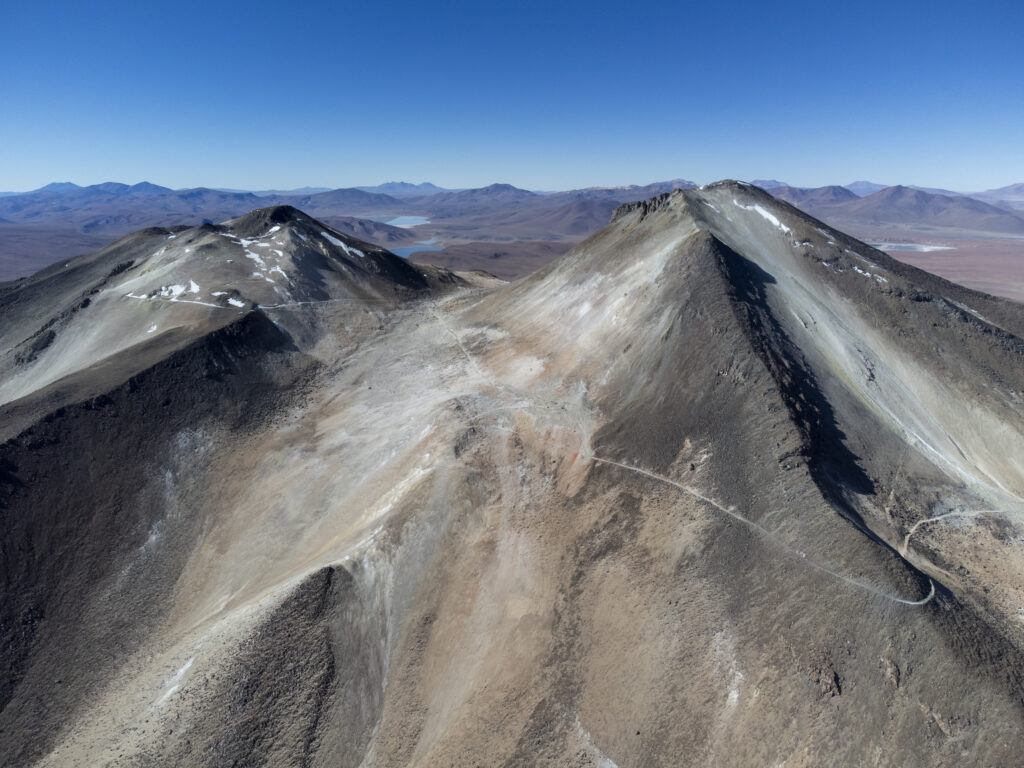
Uturuncu’s summits from above
We launch the drones and try to catch the landscape from above. Conditions are perfect, and our drones climb to around 6 000 m n. m.—probably the highest they’ve ever flown.
From above, the whole structure of the volcano is beautifully clear. Uturuncu’s main summit reaches 6 008 m n. m., the secondary peak about 5 940 m n. m. Between them you can trace the road that once ran up to the saddle at nearly 5 800 m n. m.
A short stop and the return
We spend only a few minutes beneath the slopes of this imposing volcano. Braňo’s time in Bolivia is running out, and Iva—whom we left at the lodging with Ibo—has, health issues included, had her fill of the harsh conditions we’ve faced these past two weeks.
Time to turn the car around and head back. First down from Uturuncu, then out of Eduardo Avaroa National Park, and finally back to the civilization of Uyuni.