
About two and a half years ago we were driving from Argentina to Chile via Paso de Jama. On the Chilean side, the monumental massif of the Licancabur volcano suddenly appeared on our right. The sight of this “monster” literally paralyzed me, and in that moment I knew that I had to climb it one day. From that moment on, the desire to conquer Licancabur made itself at home in me.
Let’s do it!
When during our wanderings through Bolivia we managed to reach Laguna Salada, we were suddenly close enough to attempt this ascent. We had been moving around the Altiplano for the second week already, so you could say we were at least partially acclimatized. Since Iva was struggling with a respiratory infection at the time, only Braňo undertook the ascent with me, and he ultimately gave it an unforgettable vibe.
Originally we considered using the services of local guides, but since we — like most things on our trip through Bolivia — organized it at the last minute, we couldn’t find a guide on short notice. Fortunately, the lady from the local agency at least shared basic information about the route to the summit and current conditions with us over WhatsApp.
Preparation is the key to success
The start of the trek was about an hour’s drive from our accommodation. We set the alarm for 3:00 AM. We prepared everything the evening before, so in the morning we quickly got into the car and headed along the Salvador Dalí desert road toward Lagunas Verde and Blanca.
It was at these lagoons that the Licancabur massif first revealed itself to us. However, since it was still pitch dark, all we actually saw was a faint reflection of moonlight on the snow-covered summit. And indeed, the height that awaited us was genuinely intimidating at that moment.
After a night spent finding the right path between the lagoons, we reached the trailhead just before five o’clock. We were also apparently lucky — a few kilometers before the start there was a barrier on the road, but fortunately it was open. The reason was probably that we were not the only ones attempting the summit that day. At the trailhead we saw a parked car belonging to a local travel agency.
The endless ascent
In freezing conditions we began to climb to the summit. For navigation in the dark we used the Mapy.cz app (Mapy.com), although the trail was for the most part clearly visible even at night. After roughly two hours we finally witnessed the sunrise. Its rays gradually flooded the entire valley with Lagunas Verde and Blanca. The morning light gave us optimism and pleasantly warmed us.
At the same time, however, with every meter of altitude gained the ambient temperature dropped and the lack of oxygen began to make itself felt more and more. It wasn’t dramatic, but we gradually felt growing fatigue. The solution was more frequent breaks, after which you felt briefly back in good shape. That feeling, however, disappeared after the first few steps. Gradually even the smallest tasks — changing clothes, taking a thermos out of the backpack, or simple handling of gear — became surprisingly difficult.
The mountain that fakes the summit
The sun brought one more advantage — we could finally see where we were heading. From previous experience it seemed to me that the summit ahead of us wasn’t that far and that theoretically we could make it. After a short break and breakfast we continued. The route gradually steepened, but the trail remained relatively simple and easy to follow.
Unfortunately, at first we didn’t even realize how time-consuming our frequent breaks were. The first sobering moment came around eleven in the morning when, according to GPS, we still hadn’t crossed the 5,500 meters above sea level mark. It also became clear that this mountain was literally deceiving us. What we took for the summit was always just a break in the slope, and after crossing it another seemingly endless section would unfold before us. This scenario repeated itself at least four more times during the ascent. Honestly — it did not help our morale.
Turn back or continue?
When I saw that time was slipping away faster than we needed, I suggested to Braňo that it might be wiser to turn back. Braňo, however, disagreed and proposed that we try to reach the summit.
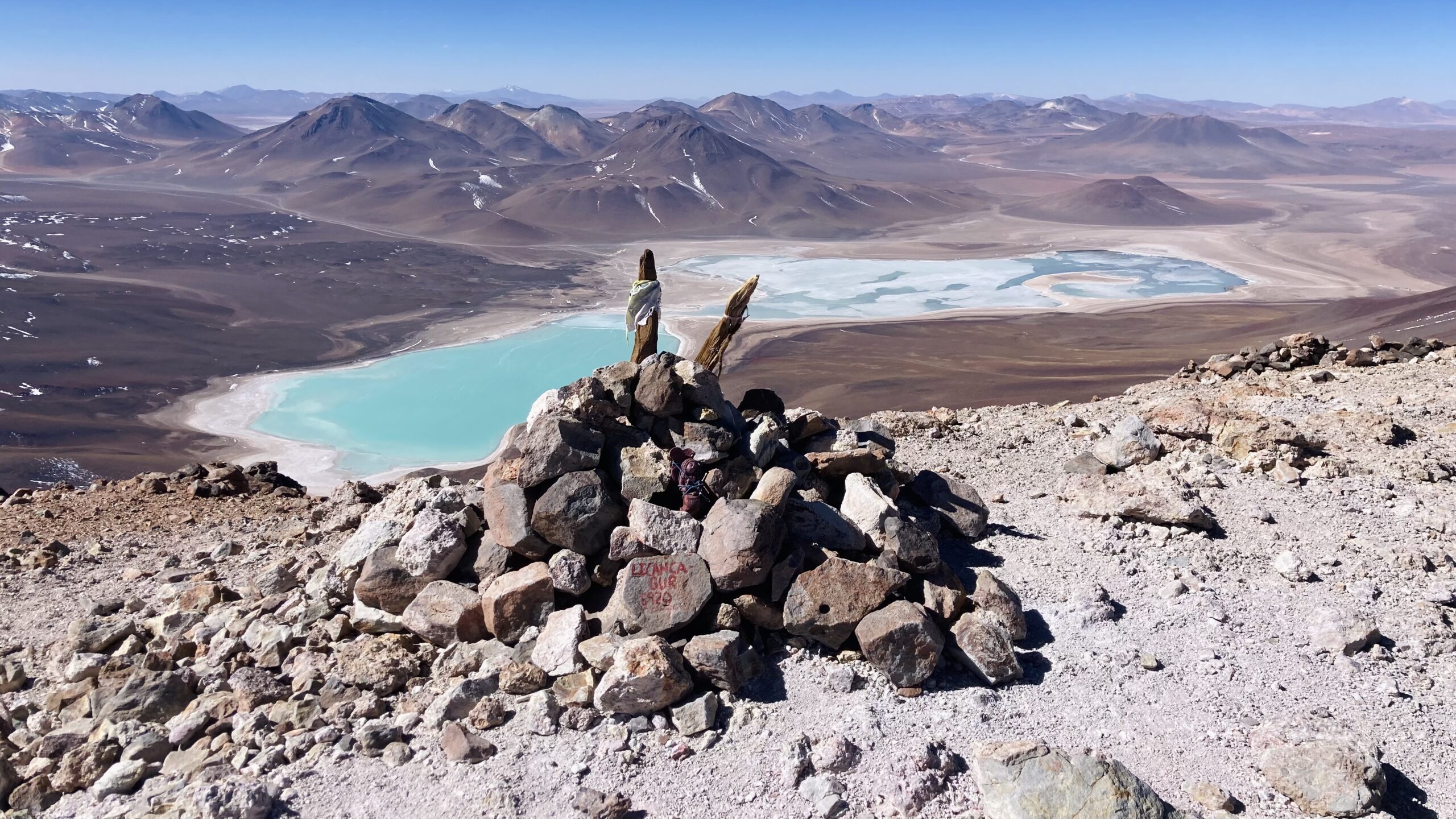
When we began literally gasping for air and my doubts about whether we could make it safely grew stronger, the terrain gradually leveled and according to GPS we were just below the summit crater. I quickened my pace. A few minutes later I suddenly saw a stick planted in a pile of rocks marking the summit.
I also got a view into the crater, which has long been filled with water and actually forms a frozen lake. A few minutes later Braňo reached the summit as well. Tired but happy with our success, we took a photo together and looked out over the endless views.
A glance at the watch made it clear — we had to go back as soon as possible. It was approaching three in the afternoon and we had roughly four hours left for the descent.
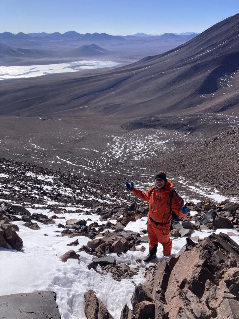
The endless descent
I believed we were past the worst, but in the end the descent became the most critical part of our trip. It turned out that in his desire to reach the summit Braňo had slightly overestimated his strength. He moved significantly slower downhill than I did, and it became clear that we probably wouldn’t reach the car in daylight.
My attempts to encourage Braňo didn’t have much effect — he did what he could. The descent turned into a fight for the last rays of sun and the remaining warmth. Shortly after the sun set, the wind picked up and the last hour of the descent was truly a torment. For me mainly because of the cold, for Braňo because of complete exhaustion.
A happy ending
In the end the story had a good ending. Braňo made it without any injury that would have significantly complicated the situation, and at around seven in the evening we successfully reached the car. Tired, frozen, but safe.
Lessons from Licancabur
Licancabur gave me more than just another summit on the list. It reminded me that at high altitudes it’s not only willpower and physical fitness that count, but above all time, humility and the ability to make the right decisions even when the goal is within reach. The mountain doesn’t forgive mistakes and every extra meter exacts its price.
If I had to take away one single lesson from this climb, it would be this: the summit is only half the journey — the return is often much more important.
Licancabur – a brief overview
Elevation: 5916 m a.s.l.
Location: the border of Bolivia and Chile
Type of volcano: stratovolcano (inactive)
Nature of ascent: technically straightforward, physically and mentally very demanding
Main risks: altitude, wind, cold, underestimating time and the descent
Interesting fact: the crater contains one of the highest lakes in the world