
The town of Llica lies on the western edge of the Salar de Uyuni, high on the Bolivian Altiplano. It’s an unassuming town that feels calm and a bit cut off from the world – and it’s precisely in such surroundings that you naturally want to explore. We have the whole afternoon ahead, we’re in no rush, and we’re looking at the map to see where we could head after visiting the Ulo crater in the area.
On the map we notice a road leading all the way to the top of the hill Cerro Hualchisa above the town. It doesn’t really look like a tourist attraction, more like a local service road. That makes it even more tempting.
The plan is simple. We’ll drive as far as we can. The rest, if necessary, we’ll finish on foot. A bit of exercise at altitude won’t hurt.
We’re already relatively well acclimatized. A recent ascent to the crater of the Tunupa volcano helped us, so this time altitude shouldn’t be a major problem. Llica lies at roughly 3,700 meters above sea level and the summit of Cerro Hualchisa rises up to 4,363 m.
The first kilometers and respect for the altitude
The road starts just outside the village and initially runs along the bottom of a wide valley under the summit itself. From the first meters it’s clear this won’t be a comfortable drive. The surface is bumpy, rocky and rutted. We go slowly but surely. We’re in no hurry.
About two kilometers past Llica, at roughly 3,950 meters above sea level, the road sharply turns left and starts to climb more steeply. A few meters later it turns again, this time to the right, and a steep ascent along a road that definitely doesn’t look in good condition is revealed before us.
Ive’s imaginary red warning lights immediately light up. She suggests that she and Ibo walk from here. I suggest one thing — first we eat properly and drink. Critical decisions at almost four thousand meters are made better on a full stomach.
We stop the car and get out. We take a break. We take out the salteñas we bought that morning in the streets of Llica and wash them down with a warm quinoa drink. At this altitude everything tastes a little more intense. The weather is pleasant. A typical Altiplano mix – the sun warms, but the air is cold and fresh. There isn’t a cloud in the sky. I think each of us is enjoying this moment.
Splitting the crew
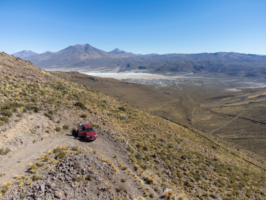
The decision comes naturally. Iva and Ibo continue on foot. Braňo and I will try to take the car a bit higher. We’ll see how far it lets us go. Braňo drives, I keep chipping in. The next section of the road is bumpy and fairly steep, but our Hilux 4×4 can handle the obstacles. We still haven’t needed to engage low range. The view ahead, however, doesn’t bode well. Actually it predicts nothing, since the road isn’t visible in the distance. We have no idea exactly how we’ll get to the saddle ahead, but as long as there’s a road, we go on. Around every bend a new section of the route reveals itself and we trust the map doesn’t lie and that we’ll reach the very top. We come to the first critical spot. Large stone steps and on each side a stone wall that probably marks someone’s property. Low range is now necessary. Slowly, carefully, literally step by step we climb further. In the end everything looks hopeful and the saddle approaches inexorably. We find ourselves in the saddle at a decent altitude of about 4,125 m asl. For the first time we see what’s on the other side. In the distance we can make out parts of the road from our earlier journey from the village of Tahua.

Exposed finish below the summit
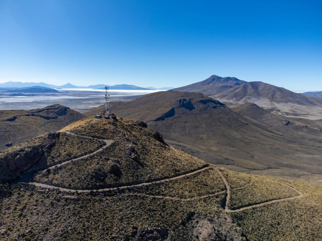
The road turns right here and continues to the summit. In places the view of the peak, dominated by a transmitter mast, is revealed. The road in these parts feels quite exposed. On one side a steep slope, on the other a steep ravine. In the end a bend on a steep slope stops our bold progress. The terrain here is extremely steep and broken. Large boulders in the middle of the road. We know we could get higher, but in the end, why push it? We’re at about 4,200 m asl. Those few vertical meters to the top we can walk.
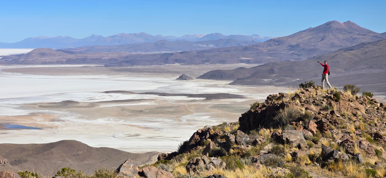
Of course, walking on a steep road at these altitudes isn’t without cost, but with regular breaks we manage the final vertical meters without major problems. From the summit we get a beautiful view. The town of Llica lies in the palm of our hand. Just turn a little and on the horizon you can still clearly make out the volcano Tunupa, even though it’s more than 50 km away. The view to the north reveals another salt plain, dominated in its middle by Lake Coipasa.
From above we suddenly have our entire access road laid out before us. What from below seemed like a lost track is a clear line from up here. While we admire the views, Iva and Ibo have already reached our parked car. It’s time to return. But of course, before leaving we photograph everything we can, and our drones had their share too. We return along the same route. First on foot and then by car. In the end the trip became a nice full stop to our stay in Llica. We spend the rest of the day in town and at our accommodation planning our next move to the town of San Pedro de Quemes. We’d like to include a visit to the Empexa baths, which are roughly on our way. We’ll see how it turns out.
Conclusion
In the end each of us reached Cerro Hualchisa as high as courage and common sense allowed on that day. Iva and Ibo chose safety and a steady pace from the first steep climb, Braňo and I pulled the car a bit higher and finished the rest on foot. Everyone had their own comfort limit — and that’s exactly how it should be in high mountains.
Bolivia is exceptional in this respect. You’ll find several roads that lead to extreme altitudes, often well above 4,000 meters. Their conditions vary — some are relatively passable, others broken and technical — but they share one thing: they can get you by car to truly exotic heights that elsewhere you would reach only after a long ascent.
Our trip to Cerro Hualchisa was in the end only a taste. Compared to the road to the volcano Uturuncu, which is among the highest drivable roads in the world, it was still relatively mild. It nevertheless clearly showed us that altitude above 4,000 meters is not a detail but a factor you must take into account.