
We discovered the Hoyada Ulo crater on the map even before leaving our accommodation in the village of Coquesa. We had originally planned to include a visit to it on our transfer day from Coquesa to Llica, but our plan was thwarted by a complicated section of road and we simply didn’t make it.
We tried again the very next day. In the morning we have street food for breakfast right in the streets of Llica, buy extra food supplies for the day and set off for the adventure.
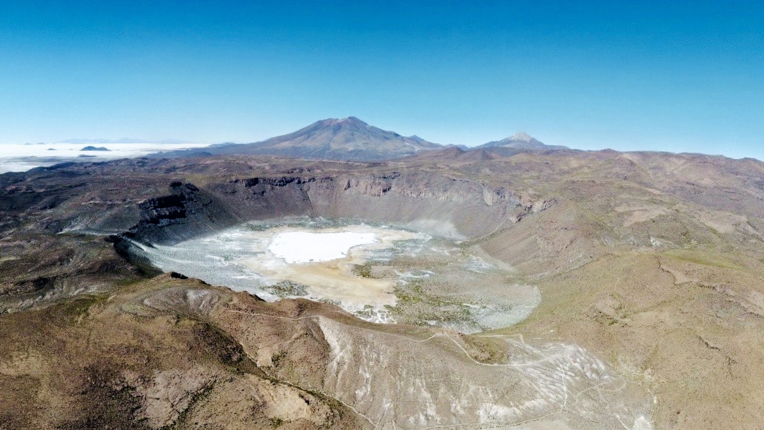
On the map this crater looks truly monumental. That alone wouldn’t be unusual—the Altiplano is full of volcanoes and craters. But this one is different. It doesn’t sit atop a prominent volcano and doesn’t continue into a typical conical shape. Instead, it’s located in the middle of a relatively flat landscape. And that’s exactly what draws us.
On the map it appears almost perfectly circular. At first glance one could easily believe that it’s not a volcanic feature but rather a meteorite impact site.
The road to the crater
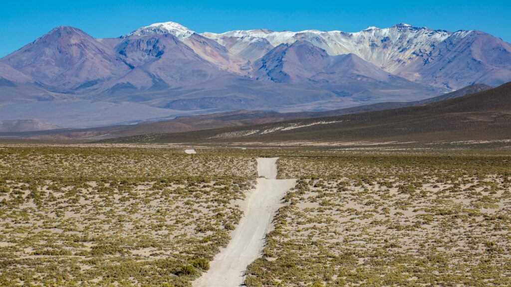
The road from Llica is typically Altiplano—dusty, stony in places, but passable. There are also so-called washboard sections that rattle the whole car no matter what speed you choose.
We have no specific expectations of the crater. It’s clearly not a very well-known tourist attraction. We found only a little information about it online and didn’t come across many photos of the place. So we’re even more surprised when we suddenly encounter a sign with an arrow reading “Hoyada Ulo” along the way.
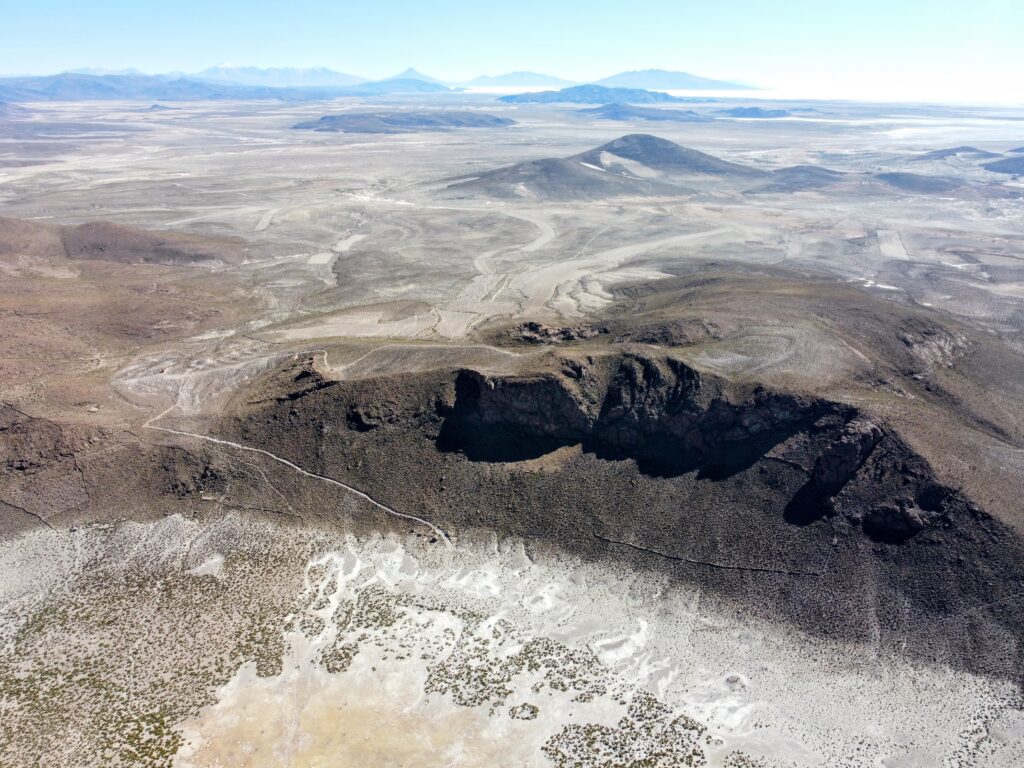
We turn off the “main” road and head toward the crater. The road slowly starts to climb, but paradoxically it’s easier to drive on than the original route. After a few minutes we find ourselves on the edge of the crater. To our surprise there’s a small parking area built here and nearby stands an unfinished building. There was probably once an attempt to make this place more attractive to tourists.
At the edge of the crater
We get out of the car to explore a bit. The crater itself is massive. Its dimensions surprise us, although from the map we had suspected they would be exceptional. The edges slowly rise above the surrounding plain and form a wide circular rim. Walking all the way around it would probably mean an all-day hike.
Interestingly, the surrounding terrain doesn’t look dramatic. No prominent lava flows, no typical volcanic cones in the immediate vicinity. Hoyada Ulo simply lies in the middle of the plain and feels like something that doesn’t quite belong here.
The crater floor is essentially a separate salt plain. The terrain is flat, the edges offer some vegetation, but the center is formed by a thin layer of salt. To capture this feature in its entirety you have to look at it from a bird’s-eye perspective. So Braňo and I launch our drones and take shots from every possible—and impossible—angle.
So that Ibo can enjoy the place too, we take a short walk with him to the nearby unfinished building. There are makeshift paths here; the terrain is easy but dusty. Ibo immediately takes advantage of that and rolls around in the dust quite thoroughly. This time we don’t even blame him for it.
Lookout above the crater
From the walk we get a view of the switchback road that leads from the parking area up to the lookout a few metres higher. Braňo and I agree that we’ll drive up there as well. Iva, mistrustful, prefers to go on foot with Ibo. So we split up for a while, but we share the same goal.
The road to the lookout is more challenging—steeper and in places eroded by water. There are deep ruts and you really have to choose the wheel track carefully. In a few minutes we’re up there and Iva catches up a few minutes later.
The lookout offers a different perspective on the crater. We’re surprised to find benches and a stone table built here as well. From this viewpoint the site offers more than we expected.
When we feel we’ve enjoyed Hoyada Ulo enough, we all get into the car and head back to the parking area. We show Iva what our car can do in this terrain. We engage low range and slowly, in first gear, descend along the broken road. Iva is frightened at times, but finally understands that the car can handle this terrain without major problems.
Will we reach the bottom?
Just as we successfully return to the parking area, Braňo comes up with a brilliant idea: “Let’s go down to the crater floor!” For a moment there’s silence. Different reactions to the idea mix inside me. There are plenty of other places nearby worth exploring. But going down might not be a bad experience either. It’s clear from Braňo that this trip would make him happy, so we get back into the car and I drive further down toward the crater floor. We saw the route from the drone and it’s marked on the map.
However, I realize that by doing this we are breaking a rule I know from skiing in extreme terrain: never go down what you haven’t gone up before.
My fears are quickly realized. After the first bend the road turns into a tank track. Huge boulders, deep ruts and sharp breaks in the terrain. Going down the car manages it more or less, but how will we fare going back up the hill?
After about 100 meters I stop and ask Braňo to go and check the terrain down below on foot. A few minutes later he returns with bad news. The road gets worse by the meter. He admits himself that the best option would be to turn the car around and go back.
But our Hilux is not a VW Polo. In steep terrain on a broken and narrow road we have no chance of turning our long vehicle around. There’s only one option left—to reverse the whole difficult section.

This proves to be an almost impossible mission. From the car I have a limited view to the rear. When I lean out of the window I can only see the left side of the vehicle. I’m reversing but I don’t have a clear idea of what I’m backing into. Stress immediately rises in the team, which Ibo senses and gets involved. As if he feels something important is happening. And he’s right.
If we fail to get the car back, what then? There’s nobody here, the nearest town Llica is tens of kilometres away. Going all the way on foot with a dog is unthinkable. The fact that we have Starlink with us gives us some sense of security. At least we have a way to call for help. The question is where from and how quickly it would arrive. We don’t want to find out. We must get the car back to the parking area at all costs.
In the end we tackle the situation as a team: Iva and Braňo stand outside the car and give me instructions through the open front windows. I combine them with what I can see sticking out the window. Step by step, literally stone by stone, we slowly move back. It takes forever, but eventually we make it.
The euphoria we experience the moment we manage to get back to the parking area is huge. What started as small curiosity could have very easily become a big problem. This time we were lucky—and had good teamwork.
Conclusion
Hoyada Ulo surprised us with its monumentality and its strange character in the middle of the plain. But then it reminded us that in Bolivia you shouldn’t rely solely on the map or drone footage.
The lesson from the trip to the crater is simple: going down is always easier than going up. And if you don’t travel the terrain first in the opposite direction, you risk more than you realize at the time.
This time the crater floor remained untouched. And maybe that’s for the best. Not every place needs to be conquered at all costs. Sometimes it’s enough to know where the boundary is—and turn back in time. If you ever find yourself here and long to visit the crater floor, do it on foot instead.
Facts about Hoyada Ulo
- Official name: Cráter de Ulo (Hoyada Ulo)
- Location: Potosí Department, Daniel Campos Province, Bolivia
- Distance from Llica: approximately 9 km west
- Elevation of the crater rim: approximately 4 000 – 4 020 m a.s.l.
- Crater diameter: approximately 2.5 – 2.6 km
- Floor type: salt pan (small salar) with an area of approximately 0.4 km²
- Type of feature: likely an erosional or volcanic depression (not a confirmed meteoritic crater)