
During our road trip through Norway we successfully arrived in the town of Bodø. This is where our next smaller adventure begins. We’re heading to the famous Norwegian archipelago, the Lofoten, but unlike most tourists we plan to first visit one of its lesser-known islands – Værøya.
We don’t have much time to visit sights in Bodø. We’re heading straight to the port. Here we struggle a bit with the organization of transport. As usual, there are several queues of cars, each for a different ferry and destination. We ask different people to find out if we’re in the right line. In the end we understand that nothing is left to chance. If you have a ticket, the staff will guide you in the right direction at the right time.
By the way, have you never heard of Værøya? Until recently neither had we. The reason we’re heading there is simple and incredible: if you buy a ticket for the Bodø – Moskenes ferry with the intention to disembark at Værøya, the resulting price is 0 Norwegian kroner. An offer you can’t refuse.
Not all ferries are the same
The sailing from Bodø to Værøy takes approximately 5.5 hours and, unlike previous ferries we’ve taken in Norway, it’s a connection across the open sea. That brings a few specifics we weren’t fully prepared for.
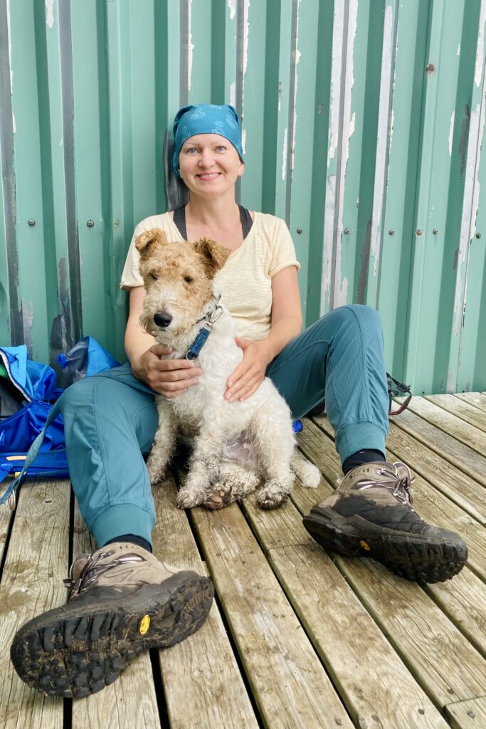
Unlike most ferries, passengers must leave the car and move to the deck. Access to the car is effectively forbidden during the crossing. The dog has it a bit more complicated – it’s not allowed on the deck and must stay in the car for the whole crossing. Despite that, we tried to ‘smuggle’ him on board, which worked for about an hour, but then the staff politely asked us to return him to the car.
We were also told that if needed, we could check on the dog once an hour directly in the car, but always only with the assistance of the ferry staff. In practice that wasn’t so simple – the crew wasn’t always available, so in the end we managed to check him only once during the crossing and once during the stopover on the island of Røst.
The end of the world called Røst
During the crossing the ferry makes a stop at the islands of Røst (or Røstlandet). It’s the westernmost and at the same time the southernmost part of the Lofoten, located almost 50 kilometers from the main islands of the archipelago.
This part of the trip had a very strange, almost mystical dimension. Røst consists of only a few rocky cliffs in the middle of nowhere. We arrived here exactly at sunset. The golden light, open sea, silhouettes of rocks and the overall remoteness created an atmosphere that’s hard to describe in words.
Only a few people disembark and embark here. There is a small fishing village, a few kilometers of roads and a functional airport. The island has more of a strategic than a tourist significance – it serves mainly fishing and as an important point in the North Atlantic, especially thanks to its position on the edge of Norwegian territory and its working airport.
Fun fact: In 2002 a coral reef Røst Reef about 43 kilometers long was discovered near Røst – one of the largest cold-water coral reefs in the world.
Where are we?
The sun is setting and we still have more than an hour of sailing to Værøy, specifically to the port in the village of Sørland.
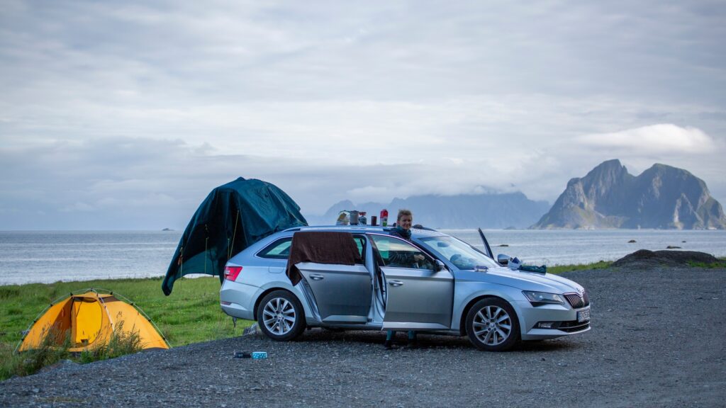
Right after disembarking we drive through several spots that could, according to the map, offer suitable places to sleep in a tent. We find the ideal spot only on the northern side of the island, at the very end of the road. It’s peaceful, quiet, beautiful scenery and we’re almost completely alone. A bonus are public toilets with running water just a short distance from where we camp for the night.
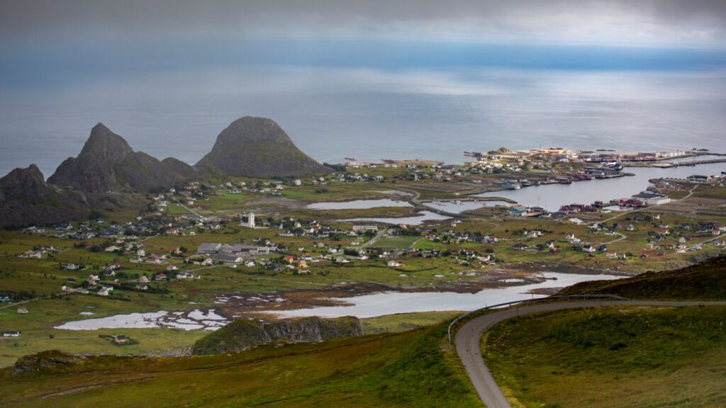
We quickly realize how small and compact Værøya actually is. It has an area of about 19 km², only around 700 inhabitants live here and there are basically only two inhabited villages – Sørland and Nordland. The road network is only a few kilometers and everything feels simple, calm and slow.
Although the sun set long ago, we still have light. During summer the sun doesn’t sink very low below the horizon. After packing and setting up the tent we finally fall asleep, exhausted after the whole day. The night was relatively pleasant and warm, but we experienced several short rain showers.
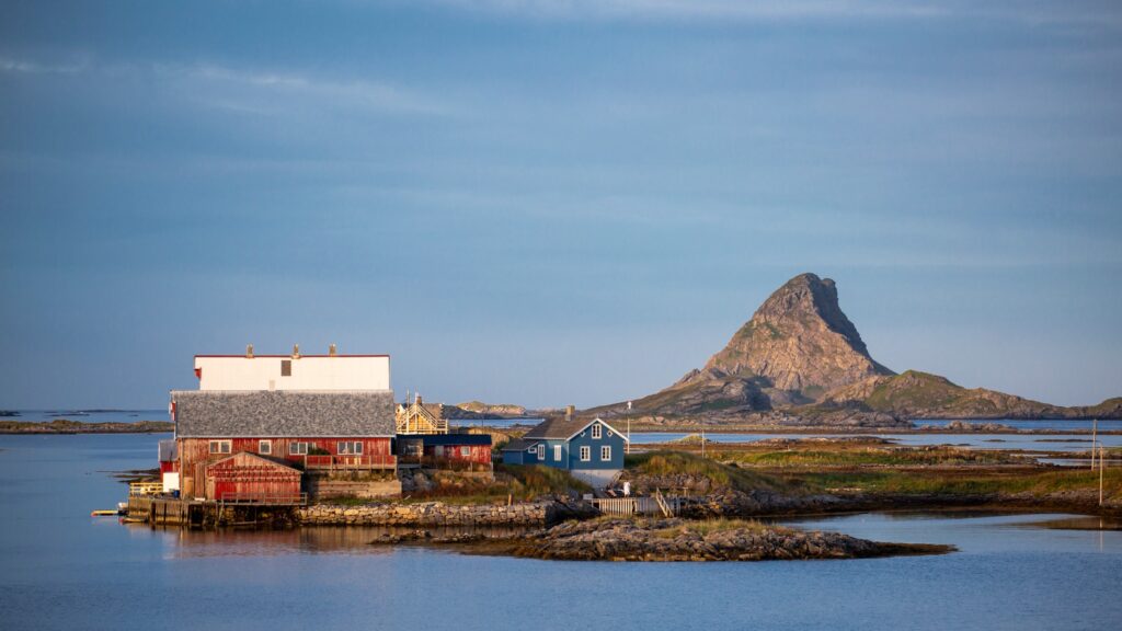
In the morning we dry what can be dried. The roof of our car turns into a small improvised kitchen. We have breakfast with a view of the nearby uninhabited island Mosken.
Nearby is also a now non-operational airport, closed due to unpredictable and sudden changes in wind. Its surroundings today serve as an ideal place for camping.
Håen
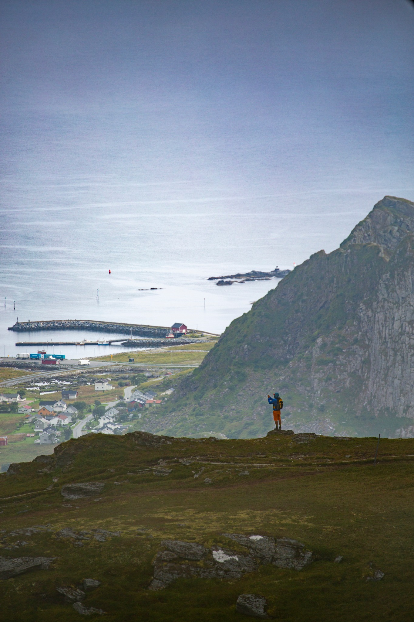
The weather improved slightly in the morning, but the forecast is merciless – increasing cloudiness is expected during the day. We move back to the village of Sørland and park in a small parking lot behind the village, where most hiking trails start.
Our goal is the summit Håen (438 m), known for views of the western part of the island. There is a military radar on the top and there is also a road called Natoveien leading here. ‘Veien’ means road in Norwegian and the name hints at its origin. This road would offer a comfortable ascent to the top, however its initial part goes through a tunnel in the mountain massif and entry into the tunnel is forbidden – whether on foot or by car.
The official hiking route goes up steep grassy slopes and only later connects to the road. The ascent is not difficult, the path is maintained and the route is clear even in poor visibility. After about an hour we reach the top. Apart from the military base we are met only by dense fog. We can’t see any of the views.
In good weather the scenery from here offers views that some call ‘the Nusa Penida of Norway’, as they resemble the view of the famous beach Kelingking Beach on the island Nusa Penida in Indonesia.
Along the ridge
At the top of Håen we wait a while in the hope that the clouds will at least partially clear. After a while it’s clear the weather won’t change, so we decide to continue.
From the top of Håen we head along the ridge north towards the summit of Hornet (346 m). At first we walk still in the fog, but gradually the weather begins to clear. At this stage we finally realize what’s to our left – steep and in places very exposed cliffs falling directly into the sea. To be safe we put the dog on a leash.
On the right, on the other hand, gentler grassy slopes descend toward the village of Sørland. Only during the descent does the fog finally start to break and we get at least partial views. In the foreground the summit Hornet appears, behind it the island Mosken and in the distance the main islands of the Lofoten archipelago.
After the descent we return to the village of Sørland without further detours. We are tired, after all we’ve had several transfers and a hike in changeable weather. A short distance from the local fire station we park the car and make ourselves a simple lunch.
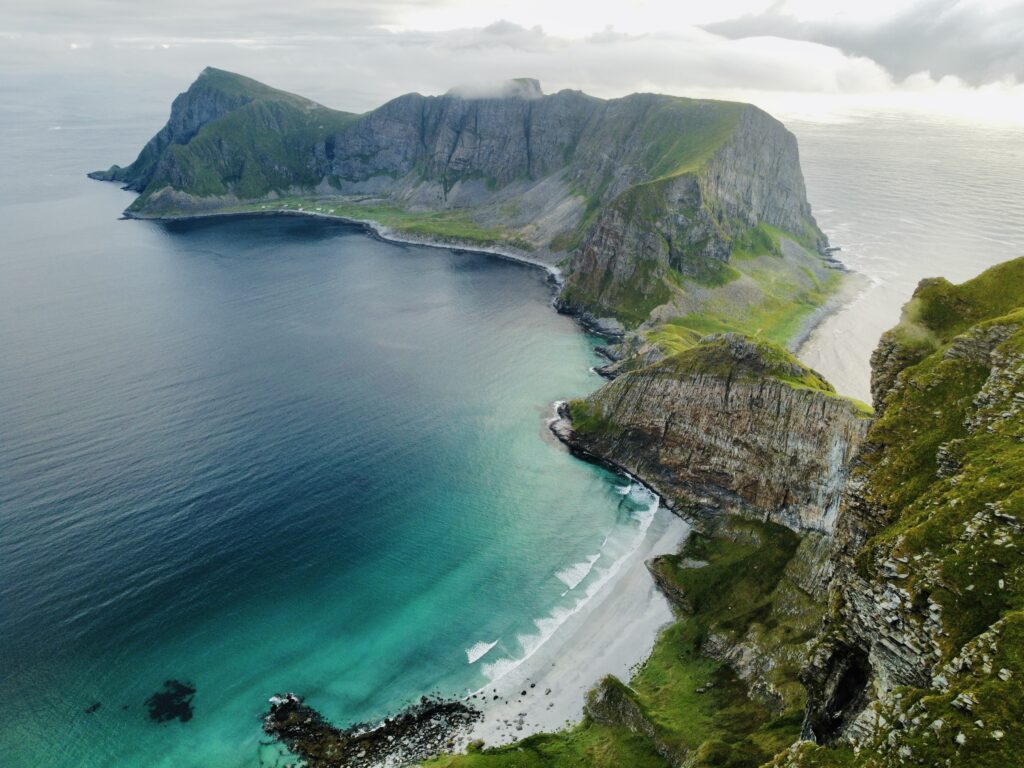
In the afternoon the weather gradually starts to improve, so I take the opportunity and fly the drone. At first I’m able to photograph only the immediate surroundings and the military station on the top of Håen, but as the clouds recede more distant views open up. Eventually I manage to capture the western part of the island we hadn’t seen on the hike because of the fog. From altitude it’s clearly visible how indented the coastline is and that there are several really nice beaches.
In the evening we move back to the port where we wait for the same ferry that brought us here the previous day. This time, however, we have a crossing towards the already more well-known and tourist-frequented parts of the Lofoten archipelago.
This stop at the end of the world was worth it. Røst was mystical already from the ferry deck and Værøya is a chapter of its own. A hard-to-describe place, all the more unique. For those 0 NOK it was definitely worth it.